-
 ×
- Startseite
- Kunstdrucke ▸
- Künstler ▸
- Kategorien ▸
- Kunststile ▸
- Bilderrahmen ▸
- Druckmedien ▸
- Alle Druckmedien
- Leinwand Leonardo (Satin)
- Leinwand Salvador (Matt)
- Leinwand Raphael (Matt)
- FineArt Foto Matt
- FineArt Foto Satin
- FineArt Foto Baryt
- FineArt Foto Hochglanz
- Aquarellkarton Munch
- Aquarellkarton Renoir
- Aquarellkarton Turner
- Aquarellkarton Dürer
- Natural Line Hemp
- Natural Line Rice
- Kozo White, 110g
- Kozo Natural, 110g
- Inbe White, 125g
- Unryu, 55g
- Bamboo, 110g
- Premio Unryu, 165g
- Murakumo Natural, 42g
- Bizan Natural, 300g
- Bizan White, 300g
- Aluverbund 3mm
- Acrylglas 5mm
- Musterset bestellen
- Welches Druckmedium passt?
Leinwand
Fotopapier
Aquarellkarton
Natural Line
Japanisches Papier
Spezialmedien
Weitere Informationen
- Hilfe & Service ▸
- Kontaktieren Sie uns
- Ihre Kunst verkaufen
- Häufig gestellte Fragen
- Offene Stellen
- Reklamation
- Muster bestellen
- Gutscheine bestellen
- Versandkosten
- Produktionszeit
- Nachhaltigkeit
- Bildrecherche
- Sonderwünsche
- Wer sind wir?
- Preispolitik
- Firmenpolitik
- Qualitätsversprechen
- Auszeichnungen
- Keilrahmen
- Passepartouts
- Zierrahmen
- Verglasung
- Fillets
- Aufhängungen
- Druckmedien
- Pflegetipps
- Impressum
- AGB
- Datenschutz
- Widerrufsrecht
Info & Service
Weitere Informationen
Wissenswertes
Rechtliches
- Shop ▸
- Kontakt


 In 3D / AR ansehen
 Bild zu Favoriten hinzufügen
 Wandfarbe ändern
 Bild in einem Raum anzeigen
.jpg "Alphabetisches Verzeichnis der Namen von Städten, Dörfern usw., die auf der Karte von Gueldre Hollandois usw. von sr. Sanson sind")


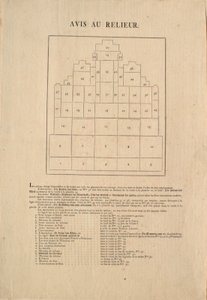


.jpg "Grundriss der dreizehn Märkte in der Stadt New York, 1833 (schwarze Tinte, mit Farbwaschung, auf Papier)")


.jpg "Die Höhen der bisher gemessenen Berge")


.jpg "Geologie")
.jpg "Abstammung der europäischen Herrscherhäuser von Kaiser Ferdinand I. bzw. König Rudolf I. von Habsburg")


.jpg "Plan der Königlichen Münze im Tower, 1701")


.jpg "Rindfleisch: Diagramm der verschiedenen Fleischstücke")

.jpg "Der Schild des Achilles nach der Beschreibung in Homers Ilias, 1815")


.jpg "„Der Mann mit sechs Köpfen“, Karikatur von Charles Maurice de Talleyrand-Périgord (1754-1838), 1815")


.jpg "Bl. 39v Karte der Magellanstraße, aus „Cosmographie Universelle“, 1555")
 Sir Francis Drake (1540-96) and (right) Thomas Cavendish (1560-92) c1595 - (MeisterDrucke-68010).jpg "Weltkarte; Vera Totius Expeditionis Nauticae, die Weltumsegelung von Sir Francis Drake (1540-96, links) und Thomas Cavendish (1560-92, rechts) darstellend, um 1595")
.jpg "Detail von Konstantinopel und dem Nahen Osten aus der Kopie der Peutingerschen Tafel")
 - (MeisterDrucke-114274).jpg "Wallis")
 pub by Joannes Janssonius Amsterdam 1660-61 (hand coloured eng - (MeisterDrucke-160707).jpg "Karte der südlichen Hemisphäre aus „Der Himmelsatlas oder Die Harmonie des Universums“ (Atlas coelestis seu harmonia macrocosmica), veröffentlicht von Joannes Janssonius, Amsterdam, 1660-61")
 - (MeisterDrucke-78391).jpg "Weltkarte")

 - (MeisterDrucke-102048).jpg "Karte von Paris, 1620 (Detail)")

.jpg "Detail Italiens aus der Kopie der Peutingerschen Tafel")
 - (MeisterDrucke-97872).jpg "Ms 4418 T II Karte 16, Plan der Zitadelle von l")
.jpg "Karte des Golfs von Bengalen, 1898")

.jpg "Karte Nr. 4 mit der Route der Armada-Flotte, gestochen von Augustine Ryther; 1588")
.jpg "Liegender weiblicher Akt mit gespreizten Beinen")

.jpg "Bauerngarten mit Sonnenblumen")

.jpg "Die Lebensreise: Jugend, 1842")
.jpg "Bauernhochzeit")
.jpg "Frühling, blumenpflückendes Mädchen, aus der Villa von Varano in Stabiae, um 15 v. Chr.-60 n. Chr.")
.jpg "Blühender Garten, Arles, Juli 1888")
.jpg "Der Seerosenteich, grüne Spiegelungen")
.jpg "Flevit super illam")

.jpg "Rosen, 1890")


 +43 4257 29415
 support@meisterdrucke.com
 Mo-Do: 7:00 - 16:00 | Fr: 7:00 - 13:00